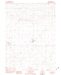
1982 Map of Hume
USGS Topo · Published 1983About this map
The town of Hume sits at the intersection of rural Illinois prairie and a busy rail network in the early 1980s. This survey records a landscape shaped by the Baltimore and Ohio and Norfolk and Western railroads, which converge near Metcalf. These rail lines define the transport patterns of the era, connecting the smaller settlements of Hildreth, Gilkey, and Melwood. The map provides specific detail for local historians and genealogists, locating the Young America Cem and the Shiloh Sch south of the main settlement. The drainage patterns of Brushy Fork and Brouilletts Creek bisect the townships of Young America and Shiloh, while the presence of the Richardson Landing Strip to the north suggests the continued importance of local aviation in this agricultural region.
Find a feature on this map
19 named features on this map. Tap any name to fly to it.
Don’t see what you’re looking for? This feature index may not catch every label — zoom into the map to look around manually.
Map Details
Editions of this 1982 Hume Map
This is the sole edition of this map. No revisions or reprints were ever made.
Other maps of this area

1946 · Kansas
USGS Topo · 1:62,500

1947 · Ridge Farm
USGS Topo · 1:62,500

1947 · Paris
USGS Topo · 1:62,500

1949 · Kansas
USGS Topo · 1:62,500

1949 · Paris
USGS Topo · 1:62,500

1953 · Indianapolis
USGS Topo · 1:250,000

1956 · Indianapolis
USGS Topo · 1:250,000

1956 · Newman
USGS Topo · 1:62,500

1957 · Indianapolis
USGS Topo · 1:250,000

1962 · Indianapolis
USGS Topo · 1:250,000