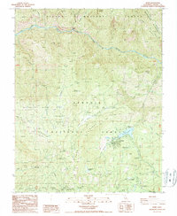
1987 Map of Hume
USGS Topo · Published 1987About this map
The Hume settlement and its centerpiece Hume Lake are documented in this 1987 provisional survey, showing the area as a developed recreation and forestry hub. The map highlights the intersection of public lands, including the Sequoia National Forest, Kings Canyon National Park, and the Monarch Wilderness. A clear focus on the history of the giant sequoias is evident through labels for the Boole Tree, the Chicago Stump, and named groves like Gen Grant Grove and Cabin Creek Grove.
Find a feature on this map
51 named features on this map. Tap any name to fly to it.
Don’t see what you’re looking for? This feature index may not catch every label — zoom into the map to look around manually.
Map Details
Editions of this 1987 Hume Map
This is the sole edition of this map. No revisions or reprints were ever made.
Other maps of this area

1903 · Tehipite
USGS Topo · 1:125,000

1905 · Tehipite
USGS Topo · 1:125,000

1922 · Trimmer
USGS Topo · 1:96,000

1924 · Dinuba
USGS Topo · 1:125,000

1942 · Dunlap
USGS Topo · 1:62,500

1944 · Dunlap
USGS Topo · 1:62,500

1948 · Fresno
USGS Topo · 1:250,000

1952 · Tehipite Dome
USGS Topo · 1:62,500

1952 · Patterson Mountain
USGS Topo · 1:62,500

1955 · Fresno
USGS Topo · 1:250,000