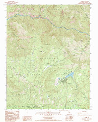
1992 Map of Hume
USGS Topo · Published 1995About this map
Hume sits at the heart of this Sierra Nevada landscape, centered on the waters of Hume Lake and the nearby Hume Station. This area is defined by its massive sequoia groves and logging history, notably preserved in the Converse Basin Grove, where the Chicago Stump and the Boole Tree stand as significant botanical landmarks. The map illustrates a high-elevation wilderness where the Kings Canyon National Park and Sierra National Forest meet, divided by prominent landforms like Deer Ridge and Hoist Ridge. Settlement is sparse, limited to the small community at Hume and Abbott, with the land primarily used for recreation and conservation. Numerous campgrounds such as Princess Campground, Aspen Hollow Campground, and Tenmile Campground are connected by Route 180, while lookouts like McGee Vista Point and Panoramic Point provide vantage points over the deep drainage of the Kings River and the high peaks of Converse Mtn.
Find a feature on this map
53 named features on this map. Tap any name to fly to it.
Don’t see what you’re looking for? This feature index may not catch every label — zoom into the map to look around manually.
Map Details
Editions of this 1992 Hume Map
This is the sole edition of this map. No revisions or reprints were ever made.
Other maps of this area

1903 · Tehipite
USGS Topo · 1:125,000

1905 · Tehipite
USGS Topo · 1:125,000

1922 · Trimmer
USGS Topo · 1:96,000

1924 · Dinuba
USGS Topo · 1:125,000

1942 · Dunlap
USGS Topo · 1:62,500

1944 · Dunlap
USGS Topo · 1:62,500

1948 · Fresno
USGS Topo · 1:250,000

1952 · Tehipite Dome
USGS Topo · 1:62,500

1952 · Patterson Mountain
USGS Topo · 1:62,500

1955 · Fresno
USGS Topo · 1:250,000