
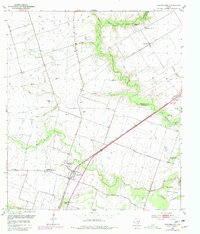
1953 Map of Hungerford
USGS Topo · Published 1954About this map
The Hungerford Oil Field dominates the central landscape of this 1953 survey, where several Gas Wells are situated along the boundary between Wharton and Fort Bend Counties. The settlement of Hungerford serves as a local hub, anchored by the Southern Pacific railroad and educational landmarks like the Hungerford Consolidated School. The hydrology of the region is defined by the winding course of the San Bernard River and its many tributaries, including West Bernard Creek and Sandy Branch, which carve through the coastal prairie. Numerous rural institutions are scattered across the map, such as the Little Zion Church and Powell Point Cemetery, providing critical points of reference for genealogists tracing family roots in this corner of East Texas. The land use pattern reflects a mid-century balance between traditional ranching on the Blossom Prairie and the industrial influence of the oil and gas sector.
Find a feature on this map
28 named features on this map. Tap any name to fly to it.
Don’t see what you’re looking for? This feature index may not catch every label — zoom into the map to look around manually.
Map Details
Editions of this 1953 Hungerford Map
2 editions found
Other maps of this area

1950 · Houston
USGS Topo · 1:250,000

1952 · Egypt
USGS Topo · 1:24,000

1953 · Kendleton
USGS Topo · 1:24,000

1953 · Wharton
USGS Topo · 1:24,000

1953 · Glen Flora
USGS Topo · 1:24,000

1953 · Boling
USGS Topo · 1:24,000

1953 · Seguin
USGS Topo · 1:250,000

1955 · Richmond
USGS Topo · 1:62,500

1956 · Wallis
USGS Topo · 1:62,500

1956 · Houston
USGS Topo · 1:250,000