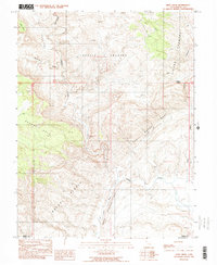
1988 Map of Hunt Draw
USGS Topo · Published 1988About this map
San Rafael Reef and the Moroni Slopes dominate this arid landscape along the Emery and Wayne county line in the late 1980s. The map illustrates a region defined by dramatic uplift and erosion, where the winding course of Muddy Creek carves through geological features like The Chute and Chimney Canyon. The presence of several adits near the center of the sheet indicates historic prospecting activity within the jagged outcrops of the reef system.
Find a feature on this map
18 named features on this map. Tap any name to fly to it.
Don’t see what you’re looking for? This feature index may not catch every label — zoom into the map to look around manually.
Map Details
Editions of this 1988 Hunt Draw Map
2 editions found
Other maps of this area

1885 · San Rafael
USGS Topo · 1:250,000

1885 · Fish Lake
USGS Topo · 1:250,000

1896 · Fish Lake
USGS Topo · 1:250,000

1952 · Wild Horse
USGS Topo · 1:62,500

1953 · Emery 4 NE
USGS Topo · 1:24,000

1953 · Emery 4 SE
USGS Topo · 1:24,000

1954 · Stinking Spring Creek 3 NW
USGS Topo · 1:24,000

1954 · Stinking Spring Creek 3 SE
USGS Topo · 1:24,000

1954 · Stinking Spring Creek 3 SW
USGS Topo · 1:24,000
1954 · Stinking Spring Creek 3 NE
USGS Topo · 1:24,000