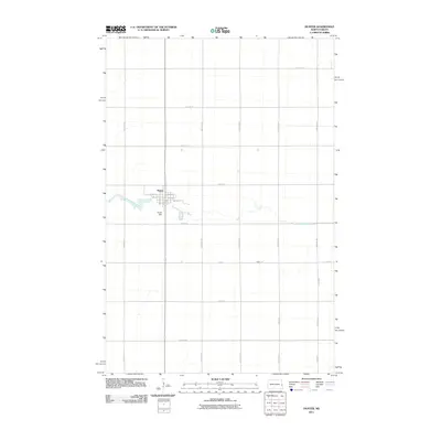
2011 Map of Hunter
USGS Topo · Published 2011About this map
The settlement of Hunter serves as the focal point of this Red River Valley survey, situated at the intersection of a precise grid of sectional roads. The landscape is defined by the winding course of the South Branch Elm River, which meanders from west to east through the center of the quadrangle. A notable point of water management on this prairie terrain is the Hunter Dam, located just south of the town's residential streets like 4th Ave W and 1st St E. The surrounding geography is almost entirely agricultural, partitioned by a network of rural routes including 12th St SE and 154th Ave SE. This survey reflects the enduring structure of North Dakota's farming country, where small town centers remain anchored by their proximity to local water sources and established section lines.
Find a feature on this map
28 named features on this map. Tap any name to fly to it.
Don’t see what you’re looking for? This feature index may not catch every label — zoom into the map to look around manually.
Map Details
Editions of this 2011 Hunter Map
This is the sole edition of this map. No revisions or reprints were ever made.
Other maps of this area

1918 · Kelso
USGS Topo · 1:62,500

1943 · Kelso
USGS Topo · 1:62,500

1952 · Grand Forks
USGS Topo · 1:250,000

1956 · Grand Forks
USGS Topo · 1:250,000

1963 · Kelso
USGS Topo · 1:24,000

1966 · Grand Forks
USGS Topo · 1:250,000
1966 · Arthur SE
USGS Topo · 1:24,000

1967 · Ayr NE
USGS Topo · 1:24,000

1967 · Blanchard
USGS Topo · 1:24,000
1967 · Grandin
USGS Topo · 1:24,000