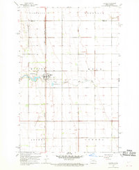
1967 Map of Hunter
USGS Topo · Published 1969About this map
The agrarian landscape of the Red River Valley is defined here by the established settlement of Hunter, which sits at the intersection of a local grid system and the north-south corridor of the Great Northern railroad. Surveyed in the late 1960s, this area of Cass County reflects a highly structured township system, with boundaries like Greenfield, Bohnsack, and Bell clearly delineated across the flat plains. The South Branch Elm River provides the primary natural drainage, meandering eastward across the central portion of the map.
Find a feature on this map
13 named features on this map. Tap any name to fly to it.
Don’t see what you’re looking for? This feature index may not catch every label — zoom into the map to look around manually.
Map Details
Editions of this 1967 Hunter Map
This is the sole edition of this map. No revisions or reprints were ever made.
Other maps of this area

1918 · Kelso
USGS Topo · 1:62,500

1943 · Kelso
USGS Topo · 1:62,500

1952 · Grand Forks
USGS Topo · 1:250,000

1956 · Grand Forks
USGS Topo · 1:250,000

1963 · Kelso
USGS Topo · 1:24,000

1966 · Grand Forks
USGS Topo · 1:250,000
1966 · Arthur SE
USGS Topo · 1:24,000

1967 · Ayr NE
USGS Topo · 1:24,000

1967 · Blanchard
USGS Topo · 1:24,000
1967 · Grandin
USGS Topo · 1:24,000