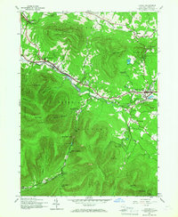
1945 Map of Hunter
USGS Topo · Published 1968About this map
The high peaks of Catskill Park dominate this mid-century landscape, centered on the historic mountain enclaves of Hunter and Tannersville. During the 1940s, the region was characterized by its cluster of seasonal camps and spiritual landmarks, including St Marys Ch, St Johns Ch, and St Francis De Sales Ch. The terrain is steeply defined by the Hunter Mountain Plateau and landmarks like the Devils Tombstone at Stony Clove Notch.
Find a feature on this map
61 named features on this map. Tap any name to fly to it.
Don’t see what you’re looking for? This feature index may not catch every label — zoom into the map to look around manually.
Map Details
Editions of this 1945 Hunter Map
2 editions found
Other maps of this area

1892 · Kaaterskill
USGS Topo · 1:62,500

1893 · Kaaterskill
USGS Topo · 1:62,500

1893 · Durham
USGS Topo · 1:62,500

1894 · Kaaterskill
USGS Topo · 1:62,500

1894 · Durham
USGS Topo · 1:62,500

1899 · Kaaterskill
USGS Topo · 1:62,500

1900 · Phoenicia
USGS Topo · 1:62,500

1901 · Gilboa
USGS Topo · 1:62,500

1903 · Gilboa
USGS Topo · 1:62,500

1903 · Phoenicia
USGS Topo · 1:62,500