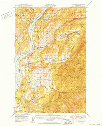
1950 Map of Hunters
USGS Topo · Published 1950About this map
Lake Roosevelt dominates the western corridor of this mid-century survey, its waters filling the Columbia River canyon following the construction of the Grand Coulee Dam. This transformation of the landscape created the Franklin D. Roosevelt Lake National Recreational Area, which sits adjacent to the Colville Indian Reservation. The map documents a significant mining heritage concentrated in the eastern highlands, featuring the Cleveland Mine, Germania Mine, and the Monitor Mine (Aband).
Find a feature on this map
53 named features on this map. Tap any name to fly to it.
Don’t see what you’re looking for? This feature index may not catch every label — zoom into the map to look around manually.
Map Details
Editions of this 1950 Hunters Map
2 editions found

Other maps of this area

1927 · Chewelah
USGS Topo · 1:125,000

1930 · Chewelah
USGS Topo · 1:125,000

1944 · Wellpinit
USGS Topo · 1:62,500

1948 · Hunters
USGS Topo · 1:62,500

1948 · Wilmont Creek
USGS Topo · 1:62,500

1948 · Lincoln
USGS Topo · 1:62,500

1948 · Turtle Lake
USGS Topo · 1:62,500

1950 · Lincoln
USGS Topo · 1:62,500

1950 · Turtle Lake
USGS Topo · 1:62,500

1950 · Wilmont Creek
USGS Topo · 1:62,500