
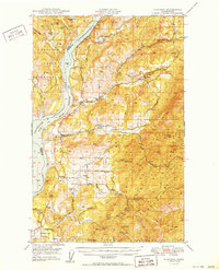
1950 Map of Hunters
USGS Topo · Published 1950About this map
Huckleberry Mountains define the central and eastern portions of this Stevens County landscape, where the extraction of silver and tungsten shaped local development mid-century. The terrain is marked by numerous industrial sites, including the prominent Cleveland Mine, Germania Mine, and the Turk Mine (Aband). To the west, the Columbia River forms the border between the Colville Indian Reservation and the Spokane Indian Reservation, its waters pooled into Lake Roosevelt behind the Coulee Dam. Community life is anchored in small settlements such as Hunters and Fruitland, supported by rural institutions like the Greenwood Grange and the Greenwood School. Genealogists may find value in the presence of the Advent Church and the Enterprise Cemetery in the southern reaches of the quadrangle.
Find a feature on this map
52 named features on this map. Tap any name to fly to it.
Don’t see what you’re looking for? This feature index may not catch every label — zoom into the map to look around manually.
Map Details
Editions of this 1950 Hunters Map
2 editions found
Other maps of this area

1927 · Chewelah
USGS Topo · 1:125,000

1930 · Chewelah
USGS Topo · 1:125,000

1944 · Wellpinit
USGS Topo · 1:62,500

1948 · Hunters
USGS Topo · 1:62,500

1948 · Wilmont Creek
USGS Topo · 1:62,500

1948 · Lincoln
USGS Topo · 1:62,500

1948 · Turtle Lake
USGS Topo · 1:62,500

1950 · Lincoln
USGS Topo · 1:62,500

1950 · Turtle Lake
USGS Topo · 1:62,500

1950 · Wilmont Creek
USGS Topo · 1:62,500