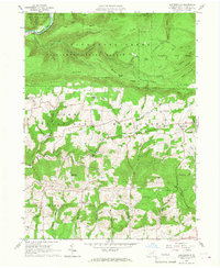
1965 Map of Huntersville
USGS Topo · Published 1967About this map
Tiadaghton State Forest covers the northern half of this mid-1960s landscape, where Loyalsock Creek carves a path through the high ridges of Allegheny Ridge and Red Ridge. The terrain is marked by family-named landmarks and rugged topography, including Smiths Knob and Dickey Knob. This area transition from the steep forest heights to the agricultural valleys of Upper Fairfield and Muncy townships.
Find a feature on this map
53 named features on this map. Tap any name to fly to it.
Don’t see what you’re looking for? This feature index may not catch every label — zoom into the map to look around manually.
Map Details
Editions of this 1965 Huntersville Map
4 editions found
Other maps of this area

1924 · Milton
USGS Topo · 1:62,500

1927 · Eagles Mere
USGS Topo · 1:48,000

1930 · Warrensville
USGS Topo · 1:62,500

1932 · Eagle Mere
USGS Topo · 1:62,500

1934 · Warrensville
USGS Topo · 1:62,500

1935 · Hughesville
USGS Topo · 1:62,500

1953 · Hughesville
USGS Topo · 1:62,500

1953 · Warrensville
USGS Topo · 1:62,500

1953 · Eagles Mere
USGS Topo · 1:62,500

1953 · Milton
USGS Topo · 1:62,500
Featured Places
- Dewey Corner, Upper Fairfield Township
- Fairfield Township, PA
- Upper Fairfield Township, PA
- Plunketts Creek Township, PA
- Mill Creek Township, PA