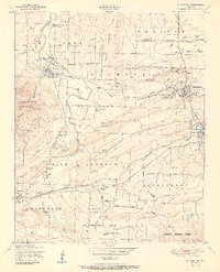
1951 Map of Huntington
USGS Topo · Published 1951About this map
The St Louis and San Francisco railroad anchors the industrial landscape of Sebastian County, connecting coal-rich settlements during the early 1950s. Mining activity is prevalent throughout the region, with numerous designated operations such as Woodson Mine, No 2 Mine, and the Northwestern Coal Company Strip Mine marking the terrain between Huntington and Midland. This survey captures the height of the local coal economy, where strip mines and deep shafts sit adjacent to rural landmarks like Gooberhull School and the Pine Grove Church. To the south, the topography rises into the Sugar Loaf Mountains and the Ouachita National Forest, while the winding James Fork and Prairie Creek provide the primary drainage for this transition from industrial valley floor to wooded highlands.
Find a feature on this map
60 named features on this map. Tap any name to fly to it.
Don’t see what you’re looking for? This feature index may not catch every label — zoom into the map to look around manually.
Map Details
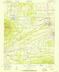
Editions of this 1951 Huntington Map
2 editions found
Other maps of this area

1879 · Poteau Mountain
USGS Topo · 1:62,500

1887 · Poteau Mountain #1
USGS Topo · 1:62,500

1887 · Poteau Mountain #2
USGS Topo · 1:62,500

1887 · Greenwood
USGS Topo · 1:62,500

1890 · Fort Smith
USGS Topo · 1:125,000

1890 · Poteau Mountain
USGS Topo · 1:125,000

1899 · Poteau Mountain
USGS Topo · 1:125,000

1906 · Barber
USGS Topo · 1:62,500

1939 · Waldron
USGS Topo · 1:62,500

1940 · Waldron
USGS Topo · 1:62,500