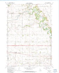
1967 Map of Huntley
USGS Topo · Published 1988About this map
The Blue Earth River meanders through the eastern portion of this Faribault County landscape, defining the topography of Verona and Prescott townships. The agricultural character of the late 1960s is evidenced by an extensive drainage network, including Judicial Ditch No 60 and Judicial Ditch No 4, which support the productive prairie land between the river and Center Creek. In the northwest, the settlement of Huntley sits along the Chicago Milwaukee St Paul and Pacific rail line, while Guckeen serves as a southern hub on the Chicago and North Western tracks. Local heritage is preserved at sites like West Verona Cem and Verona Cem, providing essential markers for genealogical research. The map also captures a moment of transition for regional infrastructure, noting a Proposed Location for a major divided highway spanning the center of the quadrangle.
Find a feature on this map
27 named features on this map. Tap any name to fly to it.
Don’t see what you’re looking for? This feature index may not catch every label — zoom into the map to look around manually.
Map Details
Editions of this 1967 Huntley Map
2 editions found
Other maps of this area

1954 · Fairmont
USGS Topo · 1:250,000

1958 · Fairmont
USGS Topo · 1:250,000

1967 · Pilot Grove
USGS Topo · 1:24,000

1967 · East Chain
USGS Topo · 1:24,000

1967 · Truman SE
USGS Topo · 1:24,000

1967 · Winnebago
USGS Topo · 1:24,000

1967 · Elmore
USGS Topo · 1:24,000

1967 · Granada
USGS Topo · 1:24,000

1967 · Huntley
USGS Topo · 1:24,000
1967 · Delavan
USGS Topo · 1:24,000