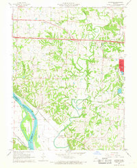
1967 Map of Huntsdale
USGS Topo · Published 1968About this map
The Missouri River corridor west of Columbia serves as the focal point for this late 1960s study, revealing the agricultural and transportation networks of Boone County. The landscape is defined by the significant floodplain around Tadpole Island and the meandering path of Perche Creek, which joins the river south of McBaine. The era's infrastructure is prominently displayed, showing the recently constructed Interstate 70 cutting across the northern reaches near Midway, contrasting with the established rail routes of the Missouri - Kansas - Texas and Missouri Pacific railroads.
Find a feature on this map
50 named features on this map. Tap any name to fly to it.
Don’t see what you’re looking for? This feature index may not catch every label — zoom into the map to look around manually.
Map Details
Editions of this 1967 Huntsdale Map
3 editions found
Other maps of this area

1886 · Jefferson City
USGS Topo · 1:125,000

1888 · Boonville
USGS Topo · 1:125,000

1890 · Moberly
USGS Topo · 1:125,000

1890 · Glasgow
USGS Topo · 1:125,000

1894 · Jefferson City
USGS Topo · 1:125,000

1917 · Sturgeon
USGS Topo · 1:62,500

1935 · Columbia
USGS Topo · 1:24,000

1940 · Columbia
USGS Topo · 1:24,000

1947 · Jefferson City
USGS Topo · 1:250,000
1948 · Columbia
USGS Topo · 1:24,000