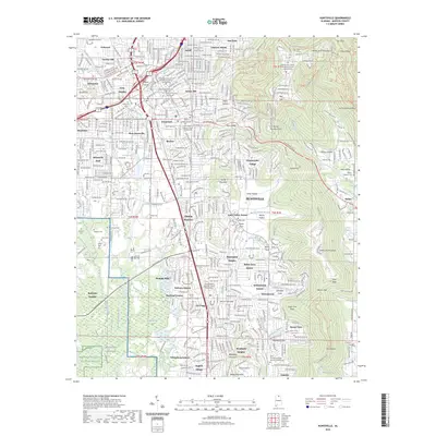
2023 Map of Huntsville
USGS Topo · Published 2023About this map
Madison County Courthouse stands at the urban heart of this modern-era study, which captures the dense residential and industrial expansion of Huntsville. The landscape is defined by the contrast between the steep rises of Monte Sano Mountain and Garth Mountain to the east and the sprawling infrastructure of Redstone Arsenal to the southwest. Significant genealogical and local interest is found in the scattered historic burying grounds, such as Sivley Cem and Merrimack Cem, which persist alongside newer neighborhoods like Whitesburg Estates and Weatherly Heights. The map traces the critical hydrological network of the Tennessee Valley, from the Huntsville Spring Branch to the protected wetlands of the Wheeler National Wildlife Refuge. Industrial history is represented by the Norfolk Southern rail line and remnants of early settlement industry at Mills Hollow.
Find a feature on this map
147 named features on this map. Tap any name to fly to it.
Don’t see what you’re looking for? This feature index may not catch every label — zoom into the map to look around manually.
Map Details
Editions of this 2023 Huntsville Map
This is the sole edition of this map. No revisions or reprints were ever made.
Other maps of this area

1888 · Scottsboro
USGS Topo · 1:125,000

1888 · Huntsville
USGS Topo · 1:125,000

1892 · Huntsville
USGS Topo · 1:125,000

1892 · Scottsboro
USGS Topo · 1:125,000

1936 · Jeff
USGS Topo · 1:24,000

1936 · Triana
USGS Topo · 1:24,000

1936 · New Hope
USGS Topo · 1:24,000

1936 · Madison
USGS Topo · 1:24,000

1936 · Meridianville
USGS Topo · 1:24,000

1936 · Moontown
USGS Topo · 1:24,000
Featured Places
- Huntsville, AL
- Bucks Canyon, Huntsville
- Forest Park, Huntsville
- Bluewood Estates, Huntsville
- Huntsville Park, Huntsville