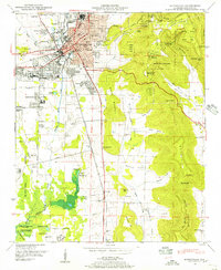
1948 Map of Huntsville
USGS Topo · Published 1956About this map
Huntsville is shown here just before its mid-century expansion, centered around Big Spring and the Southern Railway corridor. The city’s footprint is defined by industrial and residential pockets like Lincoln, Dallas, and West Huntsville, while the massive Redstone Arsenal boundary occupies the southwest. To the east, the limestone plateau of Monte Sano Mountain rises sharply, sheltering Monte Sano State Park and features like the Natural Well.
Find a feature on this map
95 named features on this map. Tap any name to fly to it.
Don’t see what you’re looking for? This feature index may not catch every label — zoom into the map to look around manually.
Map Details
Editions of this 1948 Huntsville Map
This is the sole edition of this map. No revisions or reprints were ever made.
Other maps of this area

1888 · Scottsboro
USGS Topo · 1:125,000

1888 · Huntsville
USGS Topo · 1:125,000

1892 · Huntsville
USGS Topo · 1:125,000

1892 · Scottsboro
USGS Topo · 1:125,000

1936 · Jeff
USGS Topo · 1:24,000

1936 · Triana
USGS Topo · 1:24,000

1936 · New Hope
USGS Topo · 1:24,000

1936 · Madison
USGS Topo · 1:24,000

1936 · Meridianville
USGS Topo · 1:24,000

1936 · Moontown
USGS Topo · 1:24,000