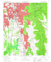
1964 Map of Huntsville
USGS Topo · Published 1966About this map
Huntsville was undergoing rapid mid-century expansion during the mid-1960s, a transformation clearly visible in the residential developments pressing against the steep slopes of Monte Sano Mountain and Green Mountain. The map details the transition from the historic core, centered near Maple Hill Cem and City Hall, toward newer suburban neighborhoods like Fleming Meadows, Parkway Estates, and Weatherly Heights. The presence of the Redstone Arsenal and the Old Huntsville-Madison County Airport underscore the city's role as a technological hub during the Space Race era. Transportation networks define the landscape, from the older tracks of the Southern Railway and the Louisville and Nashville Railroad to the modern Memorial Parkway. Between these urban areas, traditional natural features like Fagan Spring and the Huntsville Spring Branch continue to drain the valley, while the Wheeler National Wildlife Refuge marks the southern limit of development.
Find a feature on this map
112 named features on this map. Tap any name to fly to it.
Don’t see what you’re looking for? This feature index may not catch every label — zoom into the map to look around manually.
Map Details
Editions of this 1964 Huntsville Map
This is the sole edition of this map. No revisions or reprints were ever made.
Other maps of this area

1888 · Scottsboro
USGS Topo · 1:125,000

1888 · Huntsville
USGS Topo · 1:125,000

1892 · Huntsville
USGS Topo · 1:125,000

1892 · Scottsboro
USGS Topo · 1:125,000

1936 · Jeff
USGS Topo · 1:24,000

1936 · Triana
USGS Topo · 1:24,000

1936 · New Hope
USGS Topo · 1:24,000

1936 · Madison
USGS Topo · 1:24,000

1936 · Meridianville
USGS Topo · 1:24,000

1936 · Moontown
USGS Topo · 1:24,000