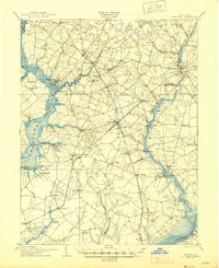
1905 Map of Hurlock
USGS Topo · Published 1945About this map
Choptank River navigation and early 20th-century rail networks define this landscape of the Maryland Eastern Shore. The map illustrates a vital period when water-borne transit, including the designated Steamboat Route and landings like Browns Landing, operated alongside the growing reach of the Baltimore Chesapeake and Atlantic RR. Significant inland settlements such as Hurlock, Federalsburg, and East New Market are shown as established hubs at the intersections of these corridors.
Find a feature on this map
63 named features on this map. Tap any name to fly to it.
Don’t see what you’re looking for? This feature index may not catch every label — zoom into the map to look around manually.
Map Details
Editions of this 1905 Hurlock Map
3 editions found
Other maps of this area

1898 · Choptank
USGS Topo · 1:125,000

1898 · St. Marys
USGS Topo · 1:125,000

1901 · Salisbury
USGS Topo · 1:62,500

1903 · Nanticoke
USGS Topo · 1:62,500

1904 · St. Michaels
USGS Topo · 1:62,500

1904 · Oxford
USGS Topo · 1:62,500

1905 · Crapo
USGS Topo · 1:62,500

1905 · Denton
USGS Topo · 1:62,500

1905 · Hurlock
USGS Topo · 1:62,500

1906 · St. Marys
USGS Topo · 1:125,000