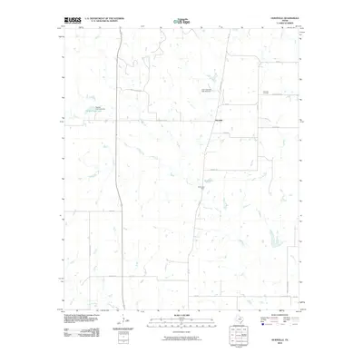
2010 Map of Hurnville
USGS Topo · Published 2010About this map
Hurnville sits at the heart of this north-central Texas landscape, serving as a focal point for a rural network of family and ranch roads in Clay County. The 2010 geography is defined by a series of engineered water resources and small drainages, most notably Long Creek and Turkey Creek. The presence of Petrolia Field Lake and Graf Lake, along with their respective dams, illustrates the local dependence on managed reservoirs for ranching and agriculture. Genealogists and local historians can trace the community's heritage through the Hurnville Cemetery and markers of former institutions such as Ikard School Rd. The road network, including names like Buster Zachry Rd and Kafer Rd, reflects the long-standing family ranching operations that have shaped this portion of the Texas plains.
Find a feature on this map
24 named features on this map. Tap any name to fly to it.
Don’t see what you’re looking for? This feature index may not catch every label — zoom into the map to look around manually.
Map Details
Editions of this 2010 Hurnville Map
This is the sole edition of this map. No revisions or reprints were ever made.
Other maps of this area

1954 · Wichita Falls
USGS Topo · 1:250,000

1955 · Lawton
USGS Topo · 1:250,000

1956 · Henrietta
USGS Topo · 1:62,500

1957 · Hastings
USGS Topo · 1:62,500

1957 · Randlett
USGS Topo · 1:62,500

1957 · Wichita Falls East
USGS Topo · 1:62,500

1958 · Wichita Falls
USGS Topo · 1:250,000
1972 · Dean
USGS Topo · 1:24,000
1972 · Charlie
USGS Topo · 1:24,000
1972 · Jolly
USGS Topo · 1:24,000