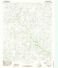
1984 Map of Hurnville
USGS Topo · Published 1985About this map
Hurnville sits at the center of this north Texas landscape, reflecting a rural settlement pattern defined by agricultural land and petroleum extraction during the mid-1980s. The terrain is deeply etched by the winding course of Long Creek, which dominates the central and eastern portions of the map, while Turkey Creek cuts through the southwestern corner. This era in Clay County is marked by a significant Oil Field presence in the northwest, where numerous wells and tanks indicate the industrial activity that sustained the local economy alongside traditional ranching. A small Cem located northeast of the main settlement provides a specific point of interest for genealogists and local historians tracing the early residents of this community. The map illustrates a network of improved and unimproved roads that connected these isolated homesteads and industrial sites before modern developments altered the rural character of the region.
Find a feature on this map
5 named features on this map. Tap any name to fly to it.
Don’t see what you’re looking for? This feature index may not catch every label — zoom into the map to look around manually.
Map Details
Editions of this 1984 Hurnville Map
This is the sole edition of this map. No revisions or reprints were ever made.
Other maps of this area

1954 · Wichita Falls
USGS Topo · 1:250,000

1955 · Lawton
USGS Topo · 1:250,000

1956 · Henrietta
USGS Topo · 1:62,500

1957 · Hastings
USGS Topo · 1:62,500

1957 · Randlett
USGS Topo · 1:62,500

1957 · Wichita Falls East
USGS Topo · 1:62,500

1958 · Wichita Falls
USGS Topo · 1:250,000
1972 · Dean
USGS Topo · 1:24,000
1972 · Charlie
USGS Topo · 1:24,000
1972 · Jolly
USGS Topo · 1:24,000