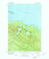
1954 Map of Huron Mountain
USGS Topo · Published 1977About this map
Lake Superior dominates the northern horizon of this mid-century survey, where the rocky coastline of the Huron Mountains meets the water at points like Huron River Point and Conway Point. The interior is defined by a dense network of high-elevation lakes and peaks, including Mount Ives and Mummy Mountain. The landscape reflects a transition from protected natural areas like the Huron National Wildlife Refuge to the managed timberlands of the Michigan State Forest. This area's isolation is evident in the sparse infrastructure, with only a few significant landmarks such as Gillet Landing on Salmon Trout Bay and the lonely Lighthouse Island offshore. Waterways like the Salmon Trout River and Pine River drain the high country, creating a complex drainage pattern through the Huron Mountains range.
Find a feature on this map
56 named features on this map. Tap any name to fly to it.
Don’t see what you’re looking for? This feature index may not catch every label — zoom into the map to look around manually.
Map Details
Editions of this 1954 Huron Mountain Map
3 editions found
Other maps of this area

1954 · Negaunee
USGS Topo · 1:62,500

1954 · Huron Mountain
USGS Topo · 1:62,500

1954 · Big Bay
USGS Topo · 1:62,500

1954 · Skanee
USGS Topo · 1:62,500

1955 · Champion
USGS Topo · 1:62,500

1956 · Michigamme
USGS Topo · 1:62,500

1958 · Hancock
USGS Topo · 1:250,000

1958 · Marquette
USGS Topo · 1:250,000

1958 · Iron River
USGS Topo · 1:250,000

1960 · Iron River
USGS Topo · 1:250,000