
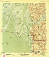
1942 Map of Hurricane
USGS Topo · Published 1942About this map
Civil War Trenches preserved on the bluffs above the Tensaw River provide a direct link to the military history of this riverine landscape near Hurricane. Surveyed just before the United States entered the second World War, this map documents the complex transition from the tidal marshes of the Mobile River delta to the upland settlements of Baldwin County. The intricate web of waterways, including Big Bayou Canot and Lizard Creek, supported a river-based economy evident in the numerous riverside points such as Upper Hall Landing and Steam Mill Landing. On the higher ground to the east, the Louisville and Nashville RR cuts through the terrain, serving Ortiz Siding and connecting rural communities like Bromley. Local social centers including St Marys Ch and Bromley Sch appear alongside family sites like Miller Cem and Wilkins Cem.
Find a feature on this map
48 named features on this map. Tap any name to fly to it.
Don’t see what you’re looking for? This feature index may not catch every label — zoom into the map to look around manually.
Map Details
Editions of this 1942 Hurricane Map
This is the sole edition of this map. No revisions or reprints were ever made.
Other maps of this area

1921 · Fairhope
USGS Topo · 1:62,500

1922 · Mobile
USGS Topo · 1:62,500

1940 · Mobile
USGS Topo · 1:31,680

1940 · Mobile
USGS Topo · 1:62,500

1941 · Chickasaw
USGS Topo · 1:31,680

1941 · Blakeley
USGS Topo · 1:31,680

1941 · Bay Minette
USGS Topo · 1:62,500

1941 · Creola
USGS Topo · 1:62,500

1941 · Fairhope
USGS Topo · 1:62,500
1942 · Blakeley
USGS Topo · 1:31,680