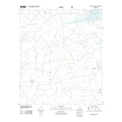
2010 Map of Hurricane Creek
USGS Topo · Published 2010About this map
Toledo Bend Reservoir dominates the northeastern corner of this Sabine County landscape, where the waters of Sandy Branch and Conner Creek meet the massive impoundment. The terrain is defined by a dense network of tributaries including Hurricane Creek, Big Sandy Creek, and South Prong Creek, which carve through the timbered region. Small settlements like Clarktown and Scrapping Valley (also labeled as Scrappin Valley) anchor the local road network, which includes Hyden Town Rd and Scrappin Valley Rd. For genealogists, the map preserves the locations of family and community landmarks such as Pleasant Hill Cemetery, Smith Cemetery, and Clark Cemetery. In the southeast, the Scrappin Valley Lake Dam creates a smaller catchment at Scrappin Valley Lake before the water continues its descent toward the regional river systems.
Find a feature on this map
31 named features on this map. Tap any name to fly to it.
Don’t see what you’re looking for? This feature index may not catch every label — zoom into the map to look around manually.
Map Details
Editions of this 2010 Hurricane Creek Map
This is the sole edition of this map. No revisions or reprints were ever made.
Other maps of this area

1944 · Negreet
USGS Topo · 1:62,500

1944 · Wiergate
USGS Topo · 1:62,500

1948 · Wiergate
USGS Topo · 1:62,500

1953 · Alexandria
USGS Topo · 1:250,000

1954 · Wiergate
USGS Topo · 1:24,000

1954 · Columbus
USGS Topo · 1:24,000

1954 · Fairdale
USGS Topo · 1:24,000

1954 · Negreet
USGS Topo · 1:62,500

1954 · Wiergate
USGS Topo · 1:62,500

1955 · Alexandria
USGS Topo · 1:250,000