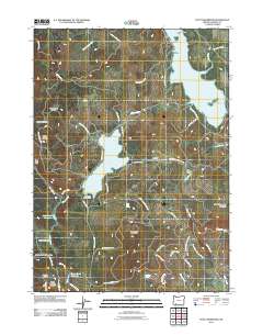
2011 Map of Hyatt Reservoir
USGS Topo · Published 2011About this map
Hyatt Reservoir and Howard Prairie Lake dominate this high-elevation landscape in Jackson County, showing the intricate water management system within the Rogue River National Frst. The map documents a geography defined by high-country prairies and glades, such as Buck Prairie and Wildcat Glades, which are interspersed among volcanic peaks like Chinquapin Mountain and Table Mountain. A network of canals and creeks, including the Howard Prairie Canal and Keene Creek, connects the various reservoirs, illustrating the mid-20th-century engineering required to manage water resources in the Cascades. Settlement is sparse, represented by locations like Burnt Creek Ranch and Summit Ranch, while the inclusion of the Hyatt Lake Campground and Green Springs Summit highlights the area's role as a recreational and transit hub in southern Oregon.
Find a feature on this map
53 named features on this map. Tap any name to fly to it.
Don’t see what you’re looking for? This feature index may not catch every label — zoom into the map to look around manually.
Map Details
Editions of this 2011 Hyatt Reservoir Map
This is the sole edition of this map. No revisions or reprints were ever made.
Other maps of this area

1891 · Ashland
USGS Topo · 1:250,000

1893 · Ashland
USGS Topo · 1:250,000

1897 · Ashland
USGS Topo · 1:250,000

1938 · Medford
USGS Topo · 1:125,000

1954 · Lakecreek
USGS Topo · 1:62,500

1954 · Ashland
USGS Topo · 1:62,500

1955 · Hyatt Reservoir
USGS Topo · 1:62,500

1955 · Mt. Mc Loughlin
USGS Topo · 1:62,500

1955 · Medford
USGS Topo · 1:250,000

1957 · Medford
USGS Topo · 1:250,000