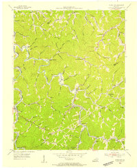
1954 Map of Hyden East
USGS Topo · Published 1955About this map
Hyden and its surrounding mountain hollows appear here in the mid-1950s, revealing a landscape defined by isolated rural schoolhouses and narrow creek-side settlements. Along the winding course of Cutshin Creek and the Middle Fork Kentucky River, the map documents a density of small community hubs that served Leslie County's timber and coal-rich terrain. Notable educational landmarks like Upper Macintosh Sch, Lower Wooton Sch, and Hendrix Sch are clearly marked alongside spiritual centers such as Brown Chapel.
Find a feature on this map
99 named features on this map. Tap any name to fly to it.
Don’t see what you’re looking for? This feature index may not catch every label — zoom into the map to look around manually.
Map Details
Editions of this 1954 Hyden East Map
This is the sole edition of this map. No revisions or reprints were ever made.
Other maps of this area

1891 · Hazard
USGS Topo · 1:125,000

1913 · Buckhorn
USGS Topo · 1:62,500

1914 · Troublesome
USGS Topo · 1:62,500

1916 · Cornettsville
USGS Topo · 1:62,500

1916 · Hyden
USGS Topo · 1:48,000

1919 · Hyden
USGS Topo · 1:62,500

1953 · Buckhorn
USGS Topo · 1:24,000

1953 · Hyden West
USGS Topo · 1:24,000

1954 · Krypton
USGS Topo · 1:24,000

1954 · Hoskinston
USGS Topo · 1:24,000