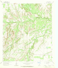
1963 Map of Hyman
USGS Topo · Published 1965About this map
The Hyman South Oil Field dominates the landscape of this West Texas quadrangle along the Howard and Mitchell county line. In the early 1960s, the area's development was defined by energy extraction and cattle ranching, evidenced by numerous Oil Wells, a sprawling Pipeline, and a network of water storage features. Surface water is channeled through ephemeral paths like Morgan Draw and Dobson Draw, which feed into Beals Creek. The reliance on artificial water sources for livestock is clear through the distribution of named stock tanks such as Arrington Tank, Magnolia Tank, and Bull Creek Tank. The small settlement of Hyman sits at the southeastern corner of the survey, representing a quiet node of activity in a terrain otherwise characterized by the transition from Howard Flat to more broken canyon lands.
Find a feature on this map
17 named features on this map. Tap any name to fly to it.
Don’t see what you’re looking for? This feature index may not catch every label — zoom into the map to look around manually.
Map Details
Editions of this 1963 Hyman Map
This is the sole edition of this map. No revisions or reprints were ever made.
Other maps of this area

1941 · Big Spring South
USGS Topo · 1:62,500

1942 · Big Spring South
USGS Topo · 1:62,500

1942 · Big Spring North
USGS Topo · 1:62,500

1951 · Iatan
USGS Topo · 1:24,000

1952 · Iatan
USGS Topo · 1:24,000

1952 · Westbrook
USGS Topo · 1:24,000

1954 · Big Spring
USGS Topo · 1:250,000

1958 · Big Spring
USGS Topo · 1:250,000

1962 · Hyman NE
USGS Topo · 1:24,000

1963 · Buffalo Draw
USGS Topo · 1:24,000