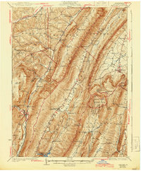
1931 Map of Hyndman
USGS Topo · Published 1944About this map
Wills Mountain and Evitts Mountain dominate this 1927 survey of southern Bedford County, creating a series of narrow, parallel valleys that shaped early Pennsylvania settlement and travel. The Cumberland Valley and Juniata Valley are dotted with a dense network of country schools like Ridge Sch and Mowry Sch, alongside numerous small communities including Hyndman and Rainsburg. This landscape is particularly rich in historic transit routes, featuring the Baltimore and Ohio Railroad and Pennsylvania Railroad, alongside ancient paths like the Warrior Path and the Horseshoe Trail.
Find a feature on this map
93 named features on this map. Tap any name to fly to it.
Don’t see what you’re looking for? This feature index may not catch every label — zoom into the map to look around manually.
Map Details
Editions of this 1931 Hyndman Map
3 editions found

Other maps of this area

1898 · Frostburg
USGS Topo · 1:62,500

1898 · Paw Paw
USGS Topo · 1:62,500

1899 · Flintstone
USGS Topo · 1:62,500

1900 · Pawpaw
USGS Topo · 1:62,500

1900 · Flintstone
USGS Topo · 1:62,500

1900 · Everett
USGS Topo · 1:62,500

1901 · Frostburg
USGS Topo · 1:62,500

1902 · Everett
USGS Topo · 1:62,500

1908 · Frostburg
USGS Topo · 1:62,500

1908 · Bedford
USGS Topo · 1:62,500