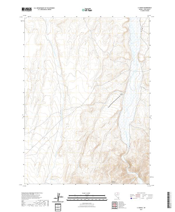
2021 Map of I L Ranch
USGS Topo · Published 2021About this map
The high-desert terrain of northern Nevada is defined here by the headwaters of the S Fork Owyhee River, which winds through the eastern portion of the landscape. This area, located within the Tuscarora Mountains, is characterized by a network of drainage systems including Fourmile Cr, Amazon Cr, and Chino Cr. The presence of the I-L Ranch Airport serves as a critical point of connectivity in this expansive ranching country, where roads are sparse and the topography dictates the movement of people and livestock. This 2021 survey illustrates the continued importance of water management and aerial access in the management of the Great Basin's remote cattle ranges, with the river valley providing a vital artery through the rugged upland basins.
Find a feature on this map
11 named features on this map. Tap any name to fly to it.
Don’t see what you’re looking for? This feature index may not catch every label — zoom into the map to look around manually.
Map Details
Editions of this 2021 I L Ranch Map
This is the sole edition of this map. No revisions or reprints were ever made.
Other maps of this area

1955 · McDermitt
USGS Topo · 1:250,000

1956 · Mt. Blitzen
USGS Topo · 1:62,500

1959 · McDermitt
USGS Topo · 1:250,000

1964 · Wilson Reservoir
USGS Topo · 1:62,500

1974 · Soldier Cap
USGS Topo · 1:24,000

1974 · Middle Draw Reservoir
USGS Topo · 1:24,000

1974 · Desert Ranch
USGS Topo · 1:24,000

1982 · Bull Run Mts
USGS Topo · 1:100,000

1982 · Tuscarora
USGS Topo · 1:100,000
1987 · Fourmile Butte
USGS Topo · 1:24,000