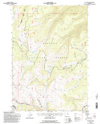
1993 Map of Ice Creek
USGS Topo · Published 1997About this map
Bighorn National Forest defines the landscape of this high-elevation terrain near the boundary of Sheridan and Big Horn counties. The area is marked by the Medicine Wheel Passage Scenic Byway, which winds past Burgess Overlook and through the complex drainage systems of the Tongue River and Little Bighorn River. This 1993 revision reveals a network of primitive roads and 4WD tracks branching off the main thoroughfare, providing access to remote features like the Gravel Pit and several high-altitude water sources including Ice Creek, Luke Creek, and a solitary Stock Pond. The topography is deeply incised by steep ravines such as Dayton Gulch and Garland Gulch, illustrating the transition from the forested plateaus to the sharp creek beds that feed into the larger river basins below.
Find a feature on this map
24 named features on this map. Tap any name to fly to it.
Don’t see what you’re looking for? This feature index may not catch every label — zoom into the map to look around manually.
Map Details
Editions of this 1993 Ice Creek Map
This is the sole edition of this map. No revisions or reprints were ever made.
Other maps of this area

1898 · Bald Mountain
USGS Topo · 1:125,000

1901 · Bald Mountain
USGS Topo · 1:125,000

1955 · Sheridan
USGS Topo · 1:250,000

1958 · Sheridan
USGS Topo · 1:250,000

1960 · Boyd Ridge
USGS Topo · 1:24,000

1960 · Granite Pass
USGS Topo · 1:24,000

1960 · Hidden Tepee Creek
USGS Topo · 1:24,000
1960 · Bald Mountain
USGS Topo · 1:24,000
1960 · Leavitt Reservoir
USGS Topo · 1:24,000

1962 · Sheridan
USGS Topo · 1:250,000