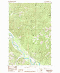
1985 Map of Idaho Gulch
USGS Topo · Published 1985About this map
The Clark Fork carves a deep valley through the rugged heart of the Lolo National Forest, serving as the primary corridor for transportation and settlement in this portion of Mineral and Missoula Counties. Near the western edge of the sheet, the small settlement of Oliverville sits along the riverbanks, just south of the confluence with Cedar Creek. The landscape is dominated by steep drainage systems like Hell Gulch Creek and Johnson Creek, which feed into the main river channel from the surrounding high country. Along the river's path, the County Airport provides a rare level landing site amidst the vertical terrain. Higher elevations are marked by the prominent Ninemile Divide, which separates the northern watersheds from the complex series of gulches and creeks to the south, including Siekrest Gulch and Idaho Gulch.
Find a feature on this map
27 named features on this map. Tap any name to fly to it.
Don’t see what you’re looking for? This feature index may not catch every label — zoom into the map to look around manually.
Map Details
Editions of this 1985 Idaho Gulch Map
This is the sole edition of this map. No revisions or reprints were ever made.
Other maps of this area

1956 · Wallace
USGS Topo · 1:250,000

1959 · Tarkio
USGS Topo · 1:62,500

1959 · Perma
USGS Topo · 1:62,500

1959 · Plains
USGS Topo · 1:62,500

1960 · Wallace
USGS Topo · 1:250,000

1960 · Superior
USGS Topo · 1:62,500

1983 · Horsehead Peak
USGS Topo · 1:24,000
1983 · Tarkio
USGS Topo · 1:24,000
1984 · Knowles
USGS Topo · 1:24,000
1985 · Quinns Hot Springs
USGS Topo · 1:24,000