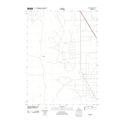
2010 Map of Idahome
USGS Topo · Published 2010About this map
Idahome sits at the intersection of agricultural transport and the eastern slopes of the Cotterel Mountains in this 2010 survey of Cassia County. The landscape is defined by its rectilinear road grid, reflecting a deeply rooted rural economy where routes like Beet Dump Rd signify the local sugar beet industry's footprint. The settlement of Idahome serves as a central point along the rail and road corridor, surrounded by family-named tracks such as Sanders Rd and Commons Way. Water remains a vital but sparse resource in this high-desert environment, marked by the course of Coe Creek and the presence of Parke Spring to the west. This map documents the persistent agricultural character of the Snake River Plain before modern shifts in regional land use.
Find a feature on this map
13 named features on this map. Tap any name to fly to it.
Don’t see what you’re looking for? This feature index may not catch every label — zoom into the map to look around manually.
Map Details
Editions of this 2010 Idahome Map
This is the sole edition of this map. No revisions or reprints were ever made.
Other maps of this area

1954 · Pocatello
USGS Topo · 1:250,000

1958 · Pocatello
USGS Topo · 1:250,000

1959 · Lake Walcott
USGS Topo · 1:62,500

1964 · Rupert SE
USGS Topo · 1:24,000

1968 · Malta NE
USGS Topo · 1:24,000

1968 · Malta
USGS Topo · 1:24,000

1968 · Idahome
USGS Topo · 1:24,000

1968 · Nibbs Creek
USGS Topo · 1:24,000

1968 · Albion
USGS Topo · 1:24,000
1968 · Connor Ridge
USGS Topo · 1:24,000