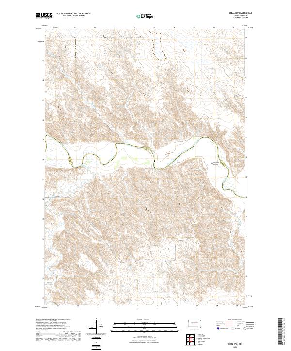
2021 Map of Ideal NW
USGS Topo · Published 2021About this map
The White River carves a serpentine path through the center of this landscape, marking the natural boundary between Lyman and Tripp Counties. Along its northern banks, the distinctive Gunny Sack Bottom sits as a prominent riparian feature, while various tributaries including Mill Iron Creek from the north and Dog Ear Creek from the south drain the surrounding uplands. The road network follows a strict sectional grid typical of the Great Plains, featuring routes like 252nd St and 260th St, though the historical footprint of a Wagon Rd in the northeastern corner suggests older transportation patterns that predated the modern township and range system. This 2021 survey documents the intersection of rural land management and the enduring physical geography of the river valley.
Find a feature on this map
16 named features on this map. Tap any name to fly to it.
Don’t see what you’re looking for? This feature index may not catch every label — zoom into the map to look around manually.
Map Details
Editions of this 2021 Ideal NW Map
This is the sole edition of this map. No revisions or reprints were ever made.
Other maps of this area

1951 · Presho 4 NE
USGS Topo · 1:24,000

1951 · Ideal NW
USGS Topo · 1:24,000

1951 · Ideal NE
USGS Topo · 1:24,000

1955 · Martin
USGS Topo · 1:250,000

1955 · Mitchell
USGS Topo · 1:250,000

1958 · Martin
USGS Topo · 1:250,000

1959 · Mitchell
USGS Topo · 1:250,000

1978 · Kennebec SW
USGS Topo · 1:24,000
1978 · Presho SE
USGS Topo · 1:24,000
1978 · Kennebec SE
USGS Topo · 1:24,000