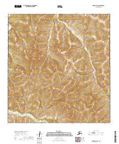
2019 Map of Iditarod A-3 SE
USGS Topo · Published 2019About this map
The Kuskokwim Mountains dominate this 2019 survey, presenting a dense network of high ridges and narrow drainage basins within the interior of Alaska. This particular landscape is defined by the boundary between the Yukon-Koyukuk Census Area and the Bethel Census Area, a line that cuts across the high terrain. In the northwest corner, the East Fork George River meanders through the foothills, representing the primary waterway for this otherwise upland region. The map reveals an area of the state that remained largely undeveloped and without established road infrastructure as of the early twenty-first century, serving as a clear record of the undisturbed topography and natural hydrology typical of the central Kuskokwim region.
Find a feature on this map
10 named features on this map. Tap any name to fly to it.
Don’t see what you’re looking for? This feature index may not catch every label — zoom into the map to look around manually.
Map Details
Editions of this 2019 Iditarod A-3 SE Map
This is the sole edition of this map. No revisions or reprints were ever made.
Other maps of this area

1950 · Sleetmute
USGS Topo · 1:250,000

1951 · Iditarod
USGS Topo · 1:250,000

1954 · Sleetmute D-4
USGS Topo · 1:63,360

1954 · Sleetmute D-3
USGS Topo · 1:63,360

1954 · Iditarod A-3
USGS Topo · 1:63,360

1954 · Iditarod A-2
USGS Topo · 1:63,360

1954 · Sleetmute
USGS Topo · 1:250,000

1956 · Iditarod
USGS Topo · 1:250,000
2019 · Sleetmute D-3 NW
USGS Topo · 1:25,000
2019 · Iditarod A-3 SW
USGS Topo · 1:25,000