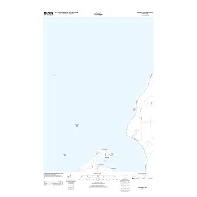
2013 Map of Idlewild
USGS Topo · Published 2013About this map
Sherwood Point and its associated shoal define the northern tip of this Door County peninsula, marking the entrance to Sawyer Harbor. This 2013 survey of the Door County shoreline shows the residential and vacation character of the community at Idlewild, where narrow roads like Cabots Point Rd and Sherwood Rd navigate the coastal contours. The map documents the localized development of Schommers Resort along the harbor's southern edge, contrasting with the submerged hazards of Larsons Reef further out in Lake Michigan. A network of coastal drives, including the prominent Bay Shore Dr, connects various points such as Little Harbor Point and Quarry Point, illustrating the late-20th and early-21st-century shift toward a primarily recreational and residential shoreline economy.
Find a feature on this map
24 named features on this map. Tap any name to fly to it.
Don’t see what you’re looking for? This feature index may not catch every label — zoom into the map to look around manually.
Map Details
Editions of this 2013 Idlewild Map
This is the sole edition of this map. No revisions or reprints were ever made.
Other maps of this area

1939 · Marinette
USGS Topo · 1:48,000

1954 · Escanaba
USGS Topo · 1:250,000

1954 · Manitowoc
USGS Topo · 1:250,000

1957 · Escanaba
USGS Topo · 1:250,000

1958 · Escanaba
USGS Topo · 1:250,000

1958 · Manitowoc
USGS Topo · 1:250,000

1960 · Sturgeon Bay
USGS Topo · 1:62,500

1961 · Little Sturgeon
USGS Topo · 1:62,500

1961 · Chambers Island
USGS Topo · 1:62,500
1963 · Marinette East
USGS Topo · 1:24,000