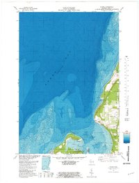
1981 Map of Idlewild
USGS Topo · Published 1981About this map
Sherwood Point anchors the entrance to Sawyer Harbor in this detailed topographic and bathymetric study of the Door County shoreline. The map reveals the intricate underwater contours of Green Bay and Sturgeon Bay, contrasting the deep waters of the bay with the developed coastal landscape. On land, the recreation and conservation focus is evident at Potawatomi State Park, where a Lookout Tower and a Ski Lift are noted near the waterfront. Industrial history is represented by several instances of a Quarry located in the township of Sevastopol, indicating the importance of local limestone extraction. The settlement of Idlewild and the smaller inlet of Little Harbor show the distribution of residential and nautical access points, including a Boat Ramp and navigation aids like the Light at the point, which guided vessels navigating the Sturgeon Bay Canal approach.
Find a feature on this map
26 named features on this map. Tap any name to fly to it.
Don’t see what you’re looking for? This feature index may not catch every label — zoom into the map to look around manually.
Map Details
Editions of this 1981 Idlewild Map
This is the sole edition of this map. No revisions or reprints were ever made.
Other maps of this area

1939 · Marinette
USGS Topo · 1:48,000

1954 · Escanaba
USGS Topo · 1:250,000

1954 · Manitowoc
USGS Topo · 1:250,000

1957 · Escanaba
USGS Topo · 1:250,000

1958 · Escanaba
USGS Topo · 1:250,000

1958 · Manitowoc
USGS Topo · 1:250,000

1960 · Sturgeon Bay
USGS Topo · 1:62,500

1961 · Little Sturgeon
USGS Topo · 1:62,500

1961 · Chambers Island
USGS Topo · 1:62,500
1963 · Marinette East
USGS Topo · 1:24,000