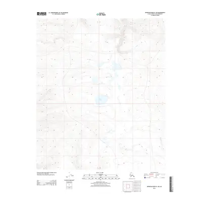
2013 Map of Ikpikpuk River B-1 SW
USGS Topo · Published 2013About this map
Puddin Lake sits at the center of this remote landscape within the Alaska North Slope Borough, a region defined by its expansive tundra and intricate hydrography. The terrain is marked by a network of seasonal watercourses and permafrost-influenced basins, including the headwaters of Wolf Cr in the north and Prince Cr flowing through the southeast. This 2013 survey provides a detailed topographic record of the area's natural drainage patterns and elevation contours, which are essential for understanding the environmental geography of the Arctic Coastal Plain. The absence of roads or permanent settlements highlights the isolation of this part of the Ikpikpuk River quadrangle, where the land remains largely untouched by industrial development.
Find a feature on this map
41 named features on this map. Tap any name to fly to it.
Don’t see what you’re looking for? This feature index may not catch every label — zoom into the map to look around manually.
Map Details
Editions of this 2013 Ikpikpuk River B-1 SW Map
This is the sole edition of this map. No revisions or reprints were ever made.
Other maps of this area

1951 · Ikpikpuk River
USGS Topo · 1:250,000

1956 · Ikpikpuk River
USGS Topo · 1:250,000
1984 · Ikpikpuk River A-1
USGS Topo · 1:63,360

1984 · Ikpikpuk River A-2
USGS Topo · 1:63,360
1985 · Ikpikpuk River B-2
USGS Topo · 1:63,360
1985 · Ikpikpuk River B-1
USGS Topo · 1:63,360
2013 · Ikpikpuk River B-2 SE
USGS Topo · 1:25,000
2013 · Ikpikpuk River B-1 NE
USGS Topo · 1:25,000
2015 · Ikpikpuk River B-1 NW
USGS Topo · 1:25,000
2015 · Ikpikpuk River B-2 NE
USGS Topo · 1:25,000