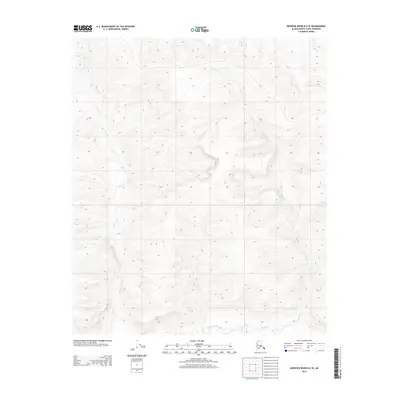
2013 Map of Ikpikpuk River B-2 SE
USGS Topo · Published 2013About this map
The upper reaches of Anak Cr and Maybe Creek define this unpopulated stretch of the North Slope. This 2013 topographic study reveals a landscape of high-latitude drainage patterns and subtle relief, where the north-flowing waters of Anak Cr cut through the western portion of the quadrangle. To the east, the headwaters of Maybe Creek—also labeled as Maybe Cr—wind through the undulating tundra. The absence of roads, structures, or established settlements emphasizes the primitive state of this remote Alaskan interior, showing only the township and range boundaries of T 1 S and R 8 W as evidence of the Public Land Survey System. For researchers of the Arctic, this map provides a precise record of the hydrologic network before any modern industrial or infrastructure changes.
Find a feature on this map
5 named features on this map. Tap any name to fly to it.
Don’t see what you’re looking for? This feature index may not catch every label — zoom into the map to look around manually.
Map Details
Editions of this 2013 Ikpikpuk River B-2 SE Map
This is the sole edition of this map. No revisions or reprints were ever made.
Other maps of this area

1951 · Ikpikpuk River
USGS Topo · 1:250,000

1956 · Ikpikpuk River
USGS Topo · 1:250,000
1984 · Ikpikpuk River A-1
USGS Topo · 1:63,360

1984 · Ikpikpuk River A-2
USGS Topo · 1:63,360
1985 · Ikpikpuk River B-2
USGS Topo · 1:63,360
1985 · Ikpikpuk River B-1
USGS Topo · 1:63,360
2013 · Ikpikpuk River B-1 SW
USGS Topo · 1:25,000
2015 · Ikpikpuk River B-1 NW
USGS Topo · 1:25,000
2015 · Ikpikpuk River B-2 NE
USGS Topo · 1:25,000
2016 · Ikpikpuk River B-2 NW
USGS Topo · 1:25,000