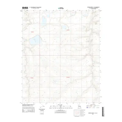
2015 Map of Ikpikpuk River C-1 SE
USGS Topo · Published 2015About this map
Square Lake dominates the upper northwestern section of this terrain, serving as a primary landmark in a landscape defined by an intricate network of drainage and elevation. The meandering course of Judy Cr winds through the eastern half of the map, while the smaller Key Cr flows across the southwestern corner. This 2015 data from the U.S. Geological Survey provides a precise view of the North Slope's topography, illustrating the complex hydrology of the Arctic coastal plain. The distribution of these water bodies and the subtle contour variations reflect the unique permafrost-influenced geography of the region, offering a detailed perspective for those studying the environmental and geological characteristics of this remote Alaskan environment.
Find a feature on this map
7 named features on this map. Tap any name to fly to it.
Don’t see what you’re looking for? This feature index may not catch every label — zoom into the map to look around manually.
Map Details
Editions of this 2015 Ikpikpuk River C-1 SE Map
This is the sole edition of this map. No revisions or reprints were ever made.
Other maps of this area

1951 · Ikpikpuk River
USGS Topo · 1:250,000

1952 · Umiat
USGS Topo · 1:250,000

1955 · Umiat C-5
USGS Topo · 1:63,360

1955 · Umiat B-5
USGS Topo · 1:63,360

1956 · Ikpikpuk River
USGS Topo · 1:250,000

1956 · Umiat
USGS Topo · 1:250,000

1964 · Umiat
USGS Topo · 1:250,000
1985 · Ikpikpuk River C-1
USGS Topo · 1:63,360
1985 · Ikpikpuk River B-1
USGS Topo · 1:63,360
2013 · Ikpikpuk River B-1 NE
USGS Topo · 1:25,000