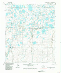
1985 Map of Ikpikpuk River C-1
USGS Topo · Published 1985About this map
National Petroleum Reserve in Alaska dominates this landscape on the North Slope, documented here during the mid-1980s. The map illustrates a complex network of thermokarst lakes and meandering waterways, including the Koluktak Lakes and Wolf Creek to the north, and Square Lake central to the quadrangle. Human activity is evidenced by the industrial infrastructure of the era, such as a localized Drill Hole and an associated Landing Strip. These features, connected by a Tractor Trail, reflect the specialized logistics required for energy exploration in the Arctic. The hydrological patterns are particularly detailed, showing the seasonal flow of Key Creek and its West Branch Key Creek as they drain toward the eastern reaches of Judy Creek.
Find a feature on this map
10 named features on this map. Tap any name to fly to it.
Don’t see what you’re looking for? This feature index may not catch every label — zoom into the map to look around manually.
Map Details
Editions of this 1985 Ikpikpuk River C-1 Map
This is the sole edition of this map. No revisions or reprints were ever made.
Other maps of this area

1951 · Ikpikpuk River
USGS Topo · 1:250,000

1952 · Umiat
USGS Topo · 1:250,000
1955 · Umiat D-5
USGS Topo · 1:63,360

1955 · Umiat C-5
USGS Topo · 1:63,360

1955 · Umiat B-5
USGS Topo · 1:63,360

1956 · Ikpikpuk River
USGS Topo · 1:250,000

1956 · Umiat
USGS Topo · 1:250,000

1964 · Umiat
USGS Topo · 1:250,000
1984 · Ikpikpuk River D-1
USGS Topo · 1:63,360
1984 · Ikpikpuk River D-2
USGS Topo · 1:63,360