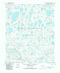
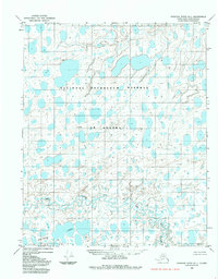
1984 Map of Ikpikpuk River D-2
USGS Topo · Published 1985About this map
The National Petroleum Reserve in Alaska dominates this landscape, a remote region of the North Slope mapped in the early 1980s. The terrain is characterized by an extensive network of thermokarst lakes and ponded water across a tundra plain, where drainage patterns are defined by the meandering Price River and Key Creek in the southern portion of the quadrangle. Scattered landforms such as Edela, Sue, and Rufina provide small points of relief in an otherwise low-lying environment. Transportation through this wilderness is limited to a singular Tractor Trail that cuts across the central section of the sheet, reflecting the specialized logistics required for movement and resource exploration in the Arctic. The map captures the area before modern infrastructure arrived, showing land lines predetermined by the Bureau of Land Management that remained largely unsurveyed on the ground at the time of publication.
Find a feature on this map
7 named features on this map. Tap any name to fly to it.
Don’t see what you’re looking for? This feature index may not catch every label — zoom into the map to look around manually.
Map Details
Editions of this 1984 Ikpikpuk River D-2 Map
This is the sole edition of this map. No revisions or reprints were ever made.
Other maps of this area

1951 · Teshekpuk
USGS Topo · 1:250,000

1951 · Ikpikpuk River
USGS Topo · 1:250,000

1955 · Teshekpuk
USGS Topo · 1:250,000
1955 · Teshekpuk A-2
USGS Topo · 1:63,360
1955 · Teshekpuk A-3
USGS Topo · 1:63,360

1955 · Teshekpuk A-1
USGS Topo · 1:63,360

1956 · Ikpikpuk River
USGS Topo · 1:250,000

1964 · Teshekpuk
USGS Topo · 1:250,000
1984 · Ikpikpuk River D-3
USGS Topo · 1:63,360
1984 · Ikpikpuk River D-1
USGS Topo · 1:63,360