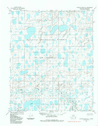
1984 Map of Ikpikpuk River D-1
USGS Topo · Published 1985About this map
National Petroleum Reserve in Alaska dominates this landscape, showing a vast Arctic wetland environment as it appeared in the early 1980s. The terrain is defined by a dense network of thaw lakes and meandering watercourses, notably the Koluktak Lakes in the southwest and the winding path of Key Creek. A series of distinctive small peaks or high points carry personal names such as Aphra, Kathy, Linda, Army, and Kristy, serving as crucial landmarks in a region devoid of roads or permanent settlements. This survey, based on 1971 aerial photography, provides a detailed look at the drainage patterns and hydrologic features of the North Slope before significant modern shifts in the permafrost landscape.
Find a feature on this map
8 named features on this map. Tap any name to fly to it.
Don’t see what you’re looking for? This feature index may not catch every label — zoom into the map to look around manually.
Map Details
Editions of this 1984 Ikpikpuk River D-1 Map
This is the sole edition of this map. No revisions or reprints were ever made.
Other maps of this area

1951 · Harrison Bay
USGS Topo · 1:250,000

1951 · Teshekpuk
USGS Topo · 1:250,000

1951 · Ikpikpuk River
USGS Topo · 1:250,000

1952 · Umiat
USGS Topo · 1:250,000

1955 · Harrison Bay
USGS Topo · 1:250,000

1955 · Teshekpuk
USGS Topo · 1:250,000
1955 · Teshekpuk A-2
USGS Topo · 1:63,360

1955 · Teshekpuk A-1
USGS Topo · 1:63,360

1955 · Harrison Bay A-5
USGS Topo · 1:63,360
1955 · Umiat D-5
USGS Topo · 1:63,360