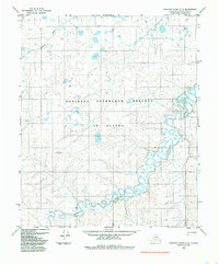
1985 Map of Ikpikpuk River C-5
USGS Topo · Published 1985About this map
National Petroleum Reserve in Alaska dominates this 1985 landscape, reflecting a specialized era of Arctic resource management and land use within the North Slope Borough. The terrain is defined by the sinuous path of the Titaluk River, which meanders across the lower half of the quadrangle, creating a complex network of oxbows and wetland patterns typical of the region's low-relief drainage. To the northwest, the Oumalik River enters the frame, further illustrating the intricate water systems that dictate movement across this tundra environment. Human presence is sparse and functional, primarily indicated by a long Tractor Trail that cuts across the northern and central sections, marking the rugged overland routes necessary for exploration and transport in this remote Alaskan interior.
Find a feature on this map
4 named features on this map. Tap any name to fly to it.
Don’t see what you’re looking for? This feature index may not catch every label — zoom into the map to look around manually.
Map Details
Editions of this 1985 Ikpikpuk River C-5 Map
This is the sole edition of this map. No revisions or reprints were ever made.
Other maps of this area

1951 · Lookout Ridge
USGS Topo · 1:250,000

1951 · Ikpikpuk River
USGS Topo · 1:250,000

1956 · Lookout Ridge
USGS Topo · 1:250,000

1956 · Ikpikpuk River
USGS Topo · 1:250,000
1984 · Ikpikpuk River D-5
USGS Topo · 1:63,360
1984 · Lookout Ridge D-1
USGS Topo · 1:63,360
1985 · Ikpikpuk River B-4
USGS Topo · 1:63,360
1985 · Lookout Ridge C-1
USGS Topo · 1:63,360
1985 · Lookout Ridge B-1
USGS Topo · 1:63,360
1985 · Ikpikpuk River C-4
USGS Topo · 1:63,360