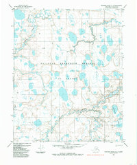
1984 Map of Ikpikpuk River D-5
USGS Topo · Published 1985About this map
The Oumalik River meanders through the heart of this landscape, carving a complex path of oxbows and wetlands within the National Petroleum Reserve in Alaska. This Arctic terrain is defined by a dense network of thaw lakes, including the concentrated Oumalik Lakes to the southeast and the winding Ishuktak Creek in the northwest. Human presence is marked by isolated outposts and survey points such as Gary, Bella, and Kyle, which appear alongside infrastructure supporting resource exploration. A prominent Tractor Trail cuts across the tundra, providing a seasonal overland link between remote sites, while a Landing Strip near the river indicates the necessity of bush planes for regional access. Several drill holes and markers like 156 E Base and 156 W Base record the technical history of geological surveying in the mid-20th century.
Find a feature on this map
20 named features on this map. Tap any name to fly to it.
Don’t see what you’re looking for? This feature index may not catch every label — zoom into the map to look around manually.
Map Details
Editions of this 1984 Ikpikpuk River D-5 Map
This is the sole edition of this map. No revisions or reprints were ever made.
Other maps of this area

1951 · Meade River
USGS Topo · 1:250,000

1951 · Lookout Ridge
USGS Topo · 1:250,000

1951 · Teshekpuk
USGS Topo · 1:250,000

1951 · Ikpikpuk River
USGS Topo · 1:250,000

1955 · Teshekpuk
USGS Topo · 1:250,000
1955 · Teshekpuk A-5
USGS Topo · 1:63,360
1955 · Teshekpuk A-4
USGS Topo · 1:63,360

1955 · Meade River
USGS Topo · 1:250,000
1955 · Meade River A-1
USGS Topo · 1:63,360

1956 · Lookout Ridge
USGS Topo · 1:250,000