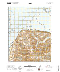
2020 Map of Iliamna A-3 SW
USGS Topo · Published 2020About this map
Katmai National Park encompasses the southern portion of this coastal survey, where the terrestrial elevations of the Aleutian Range meet the northern waters of the Pacific Ocean. The landscape is dominated by sharp topographic gradients, with steep ridgelines descending rapidly toward the shoreline. This map illustrates the intersection of vast public land preservation and the remote Alaskan coastline, capturing the transition from high-altitude volcanic terrain to the sea. The cartography focuses on natural contours and township boundaries like t13s r29w and t13s r28w, showing a region defined by its geological features rather than human settlement. The sheer verticality of the coastal mountains indicates a shoreline shaped by glacial and tectonic activity within one of the nation's most protected wilderness areas.
Find a feature on this map
6 named features on this map. Tap any name to fly to it.
Don’t see what you’re looking for? This feature index may not catch every label — zoom into the map to look around manually.
Map Details
Editions of this 2020 Iliamna A-3 SW Map
This is the sole edition of this map. No revisions or reprints were ever made.
Other maps of this area

1948 · Mt Katmai
USGS Topo · 1:250,000

1951 · Mt Katmai
USGS Topo · 1:250,000

1951 · Iliamna A-4
USGS Topo · 1:63,360

1951 · Mount Katmai D-1
USGS Topo · 1:63,360

1951 · Iliamna A-3
USGS Topo · 1:63,360

1951 · Afognak D-6
USGS Topo · 1:63,360

1952 · Iliamna
USGS Topo · 1:250,000

1952 · Afognak
USGS Topo · 1:250,000

1952 · Iliamna A-4
USGS Topo · 1:63,360
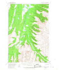
1953 · Mount Katmai D-1
USGS Topo · 1:63,360