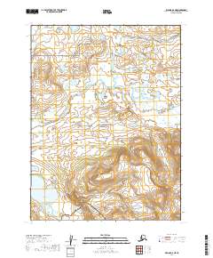
2019 Map of Iliamna A-6 NE
USGS Topo · Published 2019About this map
Katmai National Preserve and Katmai National Park divide this high-latitude landscape, where the administrative boundary separates these two federally protected wilderness areas. The terrain is defined by the convergence of major glacial drainage systems, most notably the winding course of Moraine Creek and the southern flow of Funnel Creek. In the southwest corner, the map reaches the shores of Kukaklek Lake, a significant water body situated at the foot of rising elevations. This 2019 survey documents a region largely untouched by permanent human infrastructure, illustrating the complex hydrology of the Alaska Peninsula where numerous small ponds and braided streams dominate the lowlands between mountain ranges.
Find a feature on this map
10 named features on this map. Tap any name to fly to it.
Don’t see what you’re looking for? This feature index may not catch every label — zoom into the map to look around manually.
Map Details
Editions of this 2019 Iliamna A-6 NE Map
This is the sole edition of this map. No revisions or reprints were ever made.
Other maps of this area

1951 · Iliamna A-5
USGS Topo · 1:63,360

1951 · Iliamna B-5
USGS Topo · 1:63,360

1951 · Iliamna B-6
USGS Topo · 1:63,360

1951 · Iliamna A-6
USGS Topo · 1:63,360

1952 · Iliamna
USGS Topo · 1:250,000

1952 · Iliamna A-5
USGS Topo · 1:63,360
1954 · Iliamna B-5
USGS Topo · 1:63,360
1954 · Iliamna B-6
USGS Topo · 1:63,360

1957 · Iliamna
USGS Topo · 1:250,000
2018 · Iliamna A-5 NW
USGS Topo · 1:25,000