
1951 Map of Iliamna A-6
USGS Topo · Published 1956About this map
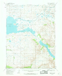
Kukaklek Lake and the interconnected waters of Narrow Cove dominate this wilderness landscape in the early 1950s. The map captures a high-elevation alpine environment defined by steep glacial topography and drainage systems like Moraine Creek and Funnel Creek. This region, surveyed before the modern era of intense tourism, shows only minimal human presence, centered around a small cluster of Cabins situated on the northern shore of Battle Lake. In the southern portion of the sheet, Pfaff Peak stands as a prominent landmark overlooking the headwaters of Nanuktuk Creek. The absence of roads or established settlements emphasizes the remote, undeveloped character of this Alaskan interior during the mid-century period, providing a baseline for researchers tracking environmental change or early backcountry structures.
Find a feature on this map
8 named features on this map. Tap any name to fly to it.
Don’t see what you’re looking for? This feature index may not catch every label — zoom into the map to look around manually.
Map Details
Editions of this 1951 Iliamna A-6 Map
2 editions found
Other maps of this area

1948 · Mt Katmai
USGS Topo · 1:250,000

1951 · Mt Katmai
USGS Topo · 1:250,000

1951 · Iliamna A-5
USGS Topo · 1:63,360

1951 · Iliamna A-7
USGS Topo · 1:63,360

1951 · Iliamna B-5
USGS Topo · 1:63,360

1951 · Mount Katmai D-4
USGS Topo · 1:63,360

1951 · Iliamna B-7
USGS Topo · 1:63,360

1951 · Mount Katmai D-3
USGS Topo · 1:63,360

1951 · Iliamna B-6
USGS Topo · 1:63,360

1952 · Iliamna
USGS Topo · 1:250,000