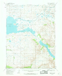
1951 Map of Iliamna A-6
USGS Topo · Published 1968About this map
Kukaklek Lake dominates the western reaches of this subarctic landscape, where the glacial legacy is written in the prominent Moraine Creek and a complex network of unnamed kettle lakes and wetlands. The terrain rises sharply toward the southeast, culminating in the high elevation of Pfaff Peak. This 1951 aerial photogrammetric survey captures the area before modern shifts in land management, showing a largely unpeopled interior where human presence is limited to a few isolated Cabins near the shores of Battle Lake. The transition from the sheltered Narrow Cove to the steep drainages of Nanuktuk Creek illustrates the hydrological divide between the expansive lake systems and the surrounding mountain ranges. This map provides a baseline record of the Seward Meridian backcountry, useful for researchers tracing the historical footprint of early wilderness structures and natural water boundaries.
Find a feature on this map
9 named features on this map. Tap any name to fly to it.
Don’t see what you’re looking for? This feature index may not catch every label — zoom into the map to look around manually.
Map Details
Editions of this 1951 Iliamna A-6 Map
2 editions found
Other maps of this area

1948 · Mt Katmai
USGS Topo · 1:250,000

1951 · Mt Katmai
USGS Topo · 1:250,000

1951 · Iliamna A-5
USGS Topo · 1:63,360

1951 · Iliamna A-7
USGS Topo · 1:63,360

1951 · Iliamna B-5
USGS Topo · 1:63,360

1951 · Mount Katmai D-4
USGS Topo · 1:63,360

1951 · Iliamna B-7
USGS Topo · 1:63,360

1951 · Mount Katmai D-3
USGS Topo · 1:63,360

1951 · Iliamna B-6
USGS Topo · 1:63,360

1951 · Iliamna A-6
USGS Topo · 1:63,360