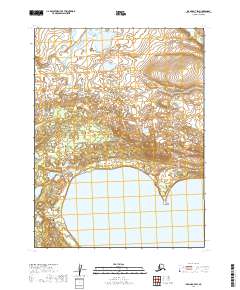
2019 Map of Iliamna A-7 SW
USGS Topo · Published 2019About this map
Katmai National Preserve dominates the southern landscape of this 2019 survey, protecting a significant expanse of wilderness in southwestern Alaska. The northern shoreline of Nonvianuk Lake curves across the bottom of the map, serving as a primary hydrologic feature for the region. This area remains largely undeveloped, defined by its complex drainage systems and the isolated flow of Nanuktuk Cr in the northeast. The map provides a detailed look at the township and range divisions, including t12s r38w, which organize this portion of the Lake and Peninsula Borough. Historically, these lands represent the transition between the preserve's rugged interior and the large freshwater bodies that characterize the Bristol Bay watershed.
Find a feature on this map
7 named features on this map. Tap any name to fly to it.
Don’t see what you’re looking for? This feature index may not catch every label — zoom into the map to look around manually.
Map Details
Editions of this 2019 Iliamna A-7 SW Map
This is the sole edition of this map. No revisions or reprints were ever made.
Other maps of this area

1948 · Mt Katmai
USGS Topo · 1:250,000

1951 · Mt Katmai
USGS Topo · 1:250,000

1951 · Mount Katmai D-5
USGS Topo · 1:63,360

1951 · Iliamna A-7
USGS Topo · 1:63,360

1951 · Iliamna A-8
USGS Topo · 1:63,360

1952 · Iliamna
USGS Topo · 1:250,000
1952 · Iliamna A-8
USGS Topo · 1:63,360

1957 · Iliamna
USGS Topo · 1:250,000

1964 · Mt. Katmai
USGS Topo · 1:250,000
2019 · Mount Katmai D-5 NW
USGS Topo · 1:25,000