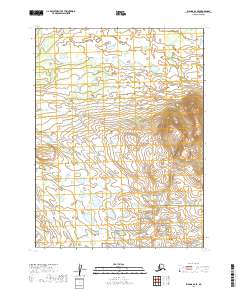
2019 Map of Iliamna B-6 SE
USGS Topo · Published 2019About this map
Katmai National Preserve occupies the southeastern corner of this map, marking a transition from the lower-lying wetlands and stream networks to more significant elevations. In the northwestern corner, Dennis Cr flows through a landscape defined by an intricate series of ponds and small lakes. This 2019 survey documents the complex hydrography of the Lake and Peninsula region, where the terrain is heavily influenced by glacial activity and drainage patterns typical of southwest Alaska. The Public Land Survey System grid lines intersect throughout, defining townships such as t9s r34w and t10s r34w, providing a framework for identifying specific locations in a region without established roads or permanent settlements on this sheet.
Find a feature on this map
8 named features on this map. Tap any name to fly to it.
Don’t see what you’re looking for? This feature index may not catch every label — zoom into the map to look around manually.
Map Details
Editions of this 2019 Iliamna B-6 SE Map
This is the sole edition of this map. No revisions or reprints were ever made.
Other maps of this area

1951 · Iliamna A-5
USGS Topo · 1:63,360

1951 · Iliamna B-5
USGS Topo · 1:63,360

1951 · Iliamna B-6
USGS Topo · 1:63,360

1951 · Iliamna A-6
USGS Topo · 1:63,360

1952 · Iliamna
USGS Topo · 1:250,000

1952 · Iliamna A-5
USGS Topo · 1:63,360
1954 · Iliamna B-5
USGS Topo · 1:63,360
1954 · Iliamna B-6
USGS Topo · 1:63,360

1957 · Iliamna
USGS Topo · 1:250,000
2018 · Iliamna A-5 NW
USGS Topo · 1:25,000