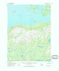
1954 Map of Iliamna C-4
USGS Topo · Published 1986About this map
Pedro Bay and Intricate Bay anchor this 1950s look at the northern reaches of Iliamna Lake. The landscape is defined by its complex hydrologic network, where the Copper River drains southward from a series of highland water bodies including Upper Copper Lake and Lower Copper Lake. To the north, the waters of Pile Bay and the larger lake are dotted with landforms such as Porcupine Island, Triangle Island, and Flat Island, while Squirrel Point marks a prominent turn in the shoreline. The topography reveals an intricate system of drainages, including Tommy Creek, and smaller inland features like Fog Lake. This survey captures the region as it existed before modern development, noting land lines that were predetermined by the Bureau of Land Management but remained unsurveyed and unmarked on the ground at the time of the field annotation.
Find a feature on this map
15 named features on this map. Tap any name to fly to it.
Don’t see what you’re looking for? This feature index may not catch every label — zoom into the map to look around manually.
Map Details
Editions of this 1954 Iliamna C-4 Map
3 editions found
Other maps of this area

1951 · Iliamna B-5
USGS Topo · 1:63,360

1952 · Iliamna
USGS Topo · 1:250,000

1954 · Iliamna D-3
USGS Topo · 1:63,360

1954 · Iliamna C-5
USGS Topo · 1:63,360

1954 · Iliamna D-4
USGS Topo · 1:63,360

1954 · Iliamna C-3
USGS Topo · 1:63,360

1954 · Iliamna B-3
USGS Topo · 1:63,360

1954 · Iliamna C-4
USGS Topo · 1:63,360

1954 · Iliamna B-4
USGS Topo · 1:63,360

1954 · Iliamna D-5
USGS Topo · 1:63,360